Chances are, you’ve used maps not only to find place or location, but also to explore an area based on a theme or criteria. For example, “I want to eat Korean food in Rome”. Where to eat Korean food in Rome is the geographic extent to a set of criteria to find what I want for planning my evening: Where Korean restaurants are located, when are they open, how are their ratings (reviews), what is the nearest public transportation to get me there and take me home, and do they take credit cards. I recently put this search to the test with an earth browser, and I must say I had a splendid night out!
The CGMap team is gearing up for the release of research plans to the world via KML, the Open Geospatial Consortium international standard for the geographic annotation and visualization in earth browsers, mobile maps, and Web-based maps. CGMap is the epitome of ICT-KM’s ‘Triple A’ approach, and once CGMap lands on the Web’s engines through KML, the project plans in CGMap will have an even greater Accessibility and Applicability potential.

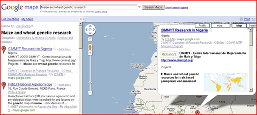
Search engines will now have geographic coordinates of the who, what, and where of CGIAR research. This means that searching for ‘maize and wheat genetic research’ will give results on CIMMYT projects, along side other relevant sources, like FAO.

Scientists, researchers and beyond … investors, partners … who use tools like Google Earth to study and plan activities will be able to build scenarios which provide a more intelligent context to their research. For example, a researcher using an earth browser to plan maize and wheat genetic research activities will be able to focus on any geographical region/location, search for maize and wheat genetic research, see results, add layers of required data (e.g: the Köppen climate classification), and save the scenario built on the fly.
Who is doing What and Where in the CGIAR?
From my first day with the ICT-KM Program, this has been an underlying question and driving force in most of my work with the Program. CGMap, launched in late 2008, is the CGIAR’s prime source of MTPs, the Medium Term Plans in which CG Centers and Challenge Programs express both their strategy and coherence to the CGIAR objectives and priorities.
Recent posts on the Social Media Tools Series have shed light on how social media tools provide researchers a more effective landscape for the collaboration and dissemination of research information. Exploiting research projects geographically will give rise to sharing and collaborating by using CGMap’s existing resources, the CGIAR project plans (who is doing what and where).
Stay tuned for future landings on maps and earth browsers of the CGIAR’s Ongoing Research: Focus on Africa (a.k.a. Eastern and Southern Africa – ESA).
August 4, 2009 at 10:19 am
Congratulations to the CGMap team. This will really enhance collaboration not only among the CGIAR centers as is with CGIAR Research in Africa Map but with other stake holders. With a lot of competition for time, most people look for where they can access a multitude of information in the shortest time possible without having to go through numerous steps and the maps definitely provide an effective way of achieving this. Looking forward to the landing!